
Today the President visits Bohol and Cebu. My blog entry The President’s visit to Dumaguete and Negros Oriental from February, 2012 gives an idea of what the visit entails. Comprehensive updates on all aspects of rescue, relief, rehabilitation can be found in Updates: Cebu and Bohol Earthquake.
Yesterday’s earthquake (see M7.1 – 2km NE of Catigbian, Philippines 2013-10-15 00:12:32 UTC) is described as follows:
The October 15, 2013 M 7.1 earthquake near the city of Catigbian on Bohol Island, Philippines, occurred as the result of shallow reverse faulting on a moderately inclined fault dipping either to the northwest, or to the southeast. The depth of the event indicates it ruptured a fault within the crust of the Sunda plate, rather than on the deeper subduction zone plate boundary interface. At the latitude of this earthquake, the Philippine Sea plate moves towards the west-northwest with respect to the Sunda plate at a rate of approximately 10 cm/yr, subducting beneath the Philippine Islands several hundred kilometers to the east of the October 15 earthquake at the Philippine Trench.
The Philippine Islands straddle a region of complex tectonics at the intersection of three major tectonic plates (the Philippine Sea, Sunda and Eurasia plates). As such, the islands are familiar with large and damaging earthquakes, and the region within 500 km of the October 15 earthquake has hosted 19 events of M6 or greater, a dozen of which have been shallow (0-70 km). One of these, a M 6.8 earthquake 70 km to the east of the October 15, 2013 event in 1990, caused several casualties.
From the Science Media Centre of Australia come these opinions:
Dr. Behzad Fatahi, Senior Lecturer of Geotechnical and Earthquake Engineering and a Chartered Professional Engineer at the Centre for Built Infrastructure Research, University of Technology Sydney (UTS):
The west-northwest convergence of the Philippine Sea plate with respect to the Sunda plate is the major source of earthquakes in Philippines. According to the available field data the slip rate between these two tectonic plates ranges from 6.5 to 13 cm.
Bohol is one of the large islands in the Philippines. The coastline, particularly in the southern section close to Bohol sea, include dense swamplands, while mostly being warm and dry. In 2012, 1996, and 1990, three earthquakes with magnitudes of 6.9, 5.6 and 6.8 struck Bohol, respectively.
On Oct 15, 2013 an earthquake with magnitude 7.2 occurred near Tagbilaran, Bohol, Philippines.
Earthquake-induced landslides have caused tremendous amount of damage throughout history. After many earthquakes, landslides had been responsible for as much or more damage than all other seismic hazards combined. Based on the geology and topography of the area, the chance of landslides occurring after this recent earthquake in Philippines is high particularly in the vicinity of Kinoguitan and Balilihan towns in the south west section of Bohol.
From Adjunct Professor Kevin McCue from the Australian Seismological Centr, who is also an adjunct professor at CQUniversity:
The revised USGS epicentre is onshore so there is no chance of a damaging tsunami. The damage in Cebu, 60km away, seems to be mostly to old masonry structures such as churches. It is apparent they don’t have a program to retrofit such vulnerable heritage buildings.”
…….
“The magnitude was more like 7.1 or 7.2. Such earthquakes are relatively common on this section of the Philippine Plate and if building codes are complied with there wouldn’t be too much damage to properly engineered structures, unfortunately these building codes are often ignored whether you are in the Philippines or Australia.
The mechanism and the path of this earthquake can make it difficult to accurately assess its size, which is why there is some variation in magnitude being reported.
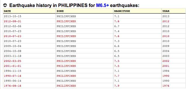
Note: See World Earthquakes List of PhilippineEarthquakes with Intensity 6.5 and above:
Our landscape and history have been shaped by earthquakes. Malacañan Palace is the seat of the chief executive because of the Great Earthquake of 1863, which destroyed the Governor-General’s Palace in Intramuros; repeated quakes resulted in the colonial style of architecture known as Earthquake Baroque. 
As the photo above of the Manila Cathedral after the Earthquake of 1888 shows, this was a constant battle between builders and nature (photo above from John Tewell’s Flickr). An interesting reading on this is Fire and Quake in the Construction of Old Manila by Greg Bankoff, in the Medieval History Journal, 2007 (you may recall that name ). It’s fitting that the first modern effort to earthquake-proof a building was undertaken by the Dominicans (the 1863 photo of Santo Domingo, the Dominican Mother Church showed they had their fair share of buildings lost to quakes) in the building of the new campus of the University of Santo Tomas:

(photo from the Flickr collection of John T. Pilot)
The past in turn links us to the present and anticipating the challenges we face in the future, as this Seismic Map suggests:

See the Earthquake Engineering Research Institute and its Learning from Earthquakes section, featuring Philippine Earthquakes. See Also Phivolcs list of Destructive Earthquakes (last updated 2008, though). Slightly newer (as of 2010) is USGS List of Philippine Earthquakes.
Catalogue of Violent and Destructive Earthquakes in the Philippines With an Appendix: Earthquakes in the Marianas Islands 1599-1909 by the Jesuit Miguel Saderra Masó, 1910, and Philippines: Luzon Earthquake of 2 August 1968 by Omote, Osawa, Skinner and Yoshimi, 1968; modern research includes Estimation of the magnitudes and epicenters of Philippine historical earthquakes by Maria Leonila P. Bautista and Kazuo Oike, 2000: the article includes an interesting map showing the location of churches built during the Spanish era. See also The Philippine historical earthquake catalog: its development, current state and future directions by Maria Leonila P. Bautista and Bartolome C. Bautista, 2004 as well as Philippine Historical Earthquakes and Lessons Learned by Maria Leonila P. Bautista and Bartolome C. Bautista, 2004.

Earthquakes aren’t just singular events –they form part of a continuing story, including the stories of fault lines whose movements cause those quakes.
Here is the Philippine Seismic Hazards Map:

And the Earthquake Density Map:

What can we do? There have been drills undertaken in response to recent earthquakes. There has been widespread discussion in the media (traditional and new) and every time an earthquake occurs, people discuss what to do and the risks involved.

Even as these discussions continue, it’s useful to revisit the existing literature.
For scenario-building: see Phivolcs Philippines Manila Earthquake Damage Scenario uploaded by Cocoy Dayao, see Evaluating the Seismic Hazards in Metro Manila, Philippines by Ivan Wong, Timothy Dawson and Mark Dober, circa 2006-2007 and Earthquake damage estimation in Metro Manila by Hiroyuki Miura, 2008 as well as Earthquake impact mitigation in poor urban areas by Kanako Iuchi and Ann-Margaret Esnard, 2008.
For reference, see: Government Information during Natural Disasters. There is also the PHIVOLCS Official Facebook Account.