Since the second season of Game of Thrones has started, quite a few viewers and readers will be hunting down maps of Westeros, the imaginary world in which the series takes place.
The Map of Westeros belongs to a tradition of Fantasy Maps, which not only help the reader visually navigate the imaginary worlds created by authors, but which lends an air of authenticity –of genuine historicity, so to speak– to a tale.
In general these maps all owe their antecedents to the map of Middle Earth. Here is a version rendered by Christopher Tolkien, son of J.R.R. Tolkien, presented in the website of Douglas Ekhart:

(See also: There is a Magnificent Rendering of Middle Earth online.) But beyond the realm of Fantasy, the use of maps for the study of history is particularly useful, though not widely used in the Philippines, where I dare say we Filipinos aren’t a particularly map-reading culture. One of the mod delightful gift I ever received was a Historical Atlas, and since then, I have always dreamed of producing a historical atlas for the Philippines. There are quite a few online historical atlas efforts (see this example and this one), and doing an image search will usually produce many historical maps uploaded by various people. There are also collections online.
Among the remarkable collections of historical maps online are the Perry Castañeda Collection; the David Rumsey Map Collection; the ; and Historical Maps of the Philippines (University of Alabama).
I’ve always been into historical maps and collections of these, and in recent months I’ve been wondering if the way forward isn’t to produce a freely-available historical atlas. After all, as noted above, many maps are already freely available. In particular, with Bataan Day coming up, it’s always puzzled me how little we use maps to understand World War 2.
Particularly useful, because they make excellent (and official) maps available to the public, are the official U.S. Army publications, such as United States Army in World War II The War in the Pacific: Triumph in the Philippines and United States Army in World War II The War in the Pacific Leyte: The Return to the Philippines (other resources and publications are in HyperWar: Pacific Theater of Operations).
The thing is, since we aren’t a map-reading culture, and because books are expensive, and teachers are few, what might be done, I’ve been wondering, to make maps more approachable or accessible to the public?
A solution seems to be Google Earth. For example, David Rumsey has shared maps from his historical collection, and integrated them with Google Maps. There are also ongoing efforts with other kinds of Historical Imagery on Google Earth. I thought that with the 70th Anniversary of the Fall of Bataan this year, we should embark on a similar effort. On April 9, The Official Gazette will unveil our initial efforts –what we hope will be a durable proof of concept in which the public can participate to enrich the results.
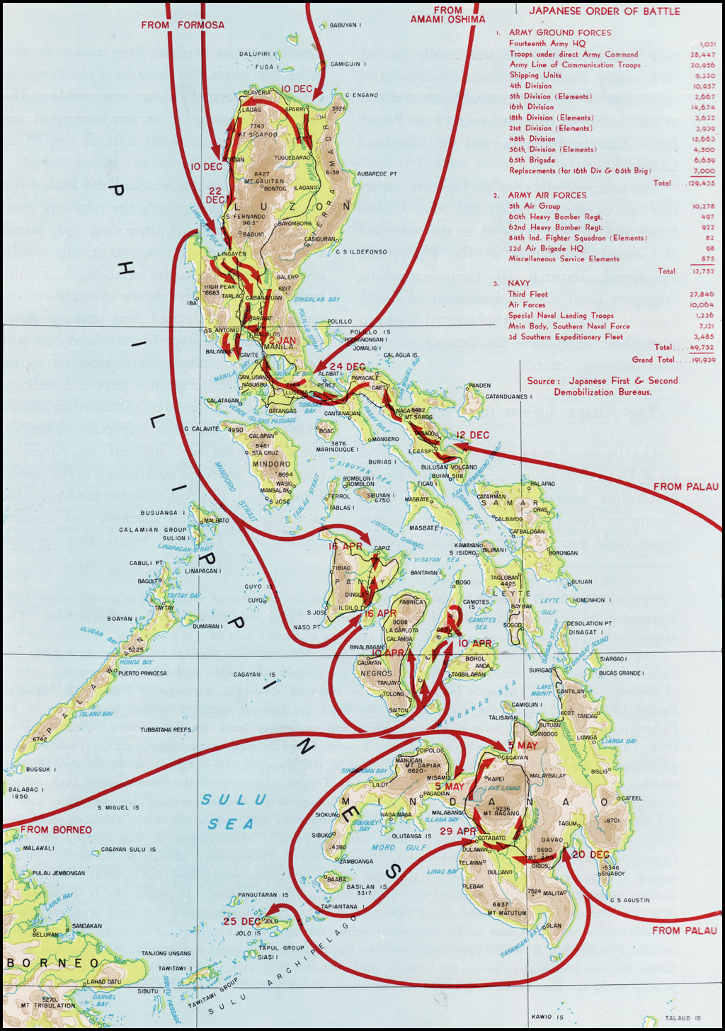
Here are some examples of how the project works. Take this official map, of the Japanese Imperial Army’s Order of Battle for the invasion of the Philippines:

In and of itself it is a very informative map, particularly to those familiar with military maps. The added bonus of integrating such maps into Google Earth is that it provides context –everything else that couldn’t fit into the dimensions of the paper on which the map was printed. So, you get the map and overlay it on the globe, and you get:
 \
\
Once we release the Google Earth file for viewers to explore, you’ll see what I mean. Or take this other map, much more simplified, outlining the Japanese invasion path from December 8, 1941 to January 8, 1942:

Overlaying it on Google Earth will situate the map in terms of the overall map of the Philippines: and you can compare and contrast it, or, in this case, actually integrate it, with another map, in this case, the Order of Battle Map I showed you earlier:
Take another example: this map, which shows the Bataan Campaign, from start to finish. Again, it’s the sort of map military historians can read easily, but which the layman may need some explaining beforehand to come to grips with; one limitation of a map like this, is that it provides everything you need to know, in military terms, but doesn’t –because of space constraints– provide context.

Here is what I mean: you can just as easily focus on the Bataan Campaign while also seeing the campaign in the context of the surrounding geography, for example, proximity to Manila. This gives you visual cues to what the history books say, such as people hearing the bombardment of Corregidor from Manila, and so on.

You can zoom in and, in this case, zoom out:
Take another event. Here is a map you can easily find online, of the path of the Death March.

To my mind, however, overlaying the map on Luzon immediately brings home just how long the Death March was, first of all; and also, situates the map above, in Luzon as a whole.
You can zoom in as well and also get a grasp of the distances involved, etc.
Here is a later map, showing the different routes taken by secret agents who were sent to the Philippines to find out what was going on during the Japanese Occupation. Route No. 5, for example, shows the tortuous path taken by Col. Emigdio Cruz, who was sent by Quezon to talk to officials he’d left behind (Cruz received the Medal of Valor for his exploits).

Again, a map like this can be easily overlaid on Google Earth.
Maps such as this one —the plan for the Leyte Landing— is also very instructive, militarily speaking, but overlaying it on Google Earth helps restore a sense of scale.

Here you can see the plans in the context of the Visayas:
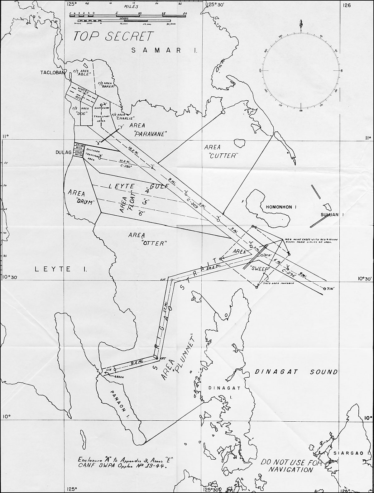
Online you can also find this map, one of those used in the planning for the Leyte Landing. It shows the routes for minesweepers.

Again, the rather abstract planning map, can be overlaid on the part of the country it covers, and you can see the map in a more regional context.
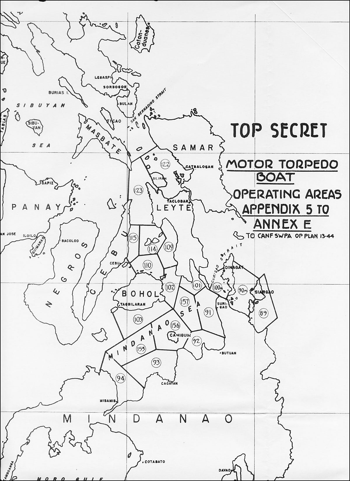
There’s this map, too, which was probably the same size as the map above, but overlaying it on the area it covers shows how much larger the scale involved is:

Here is the same map, overlaid on the territory it portrays, mapping out the operating areas for motor torpedo boats.
The Battle for Manila in 1945 has been portrayed in fine maps such as this one:

But overlaying it on the actual map of Manila can tell you how intense the fighting was, and in a limited part of the city; those who read about it, will then also see why some parts of Manila suffered less than say, Intramuros:
Or take this map, which shows the encirclement and capture of Manila:

I think that once our collection is made available on Google Earth, viewers will be fascinated with what overlaying the map above, on present-day Metro Manila, will tell you. Among other things, the enormous area that has been reclaimed from Manila Bay since the war years; and the changes in names for streets and even parts of the metropolis; or the military actions that took place in places as far afield, as say, Montalban.

Many of these maps can be found at Reports of General MacArthur: THE CAMPAIGNS OF MACARTHUR IN THE PACIFIC.
Next time, more on integrating historical maps with Google Earth.